IDA - Satellite Derived Bathymetry
The IDA software enables fast water depth mapping from satellite imagery using the latest physics-based model inversion methods.
Mapping bathymetry from satellite imagery has a long history, but traditional methods require known depth data for calibration and may have poor transferability outside the calibration area. The latest physics-based methods operate without the need for known depths and are more adaptable to environmental variation. IDA (Image Data Analysis) is a user-friendly software package which includes a fast implementation of the physics-based bathymetry method and other tools for general remote sensing of shallow water areas. The software has been in continual development over the last 15 years and includes several state-of-the-art algorithms.
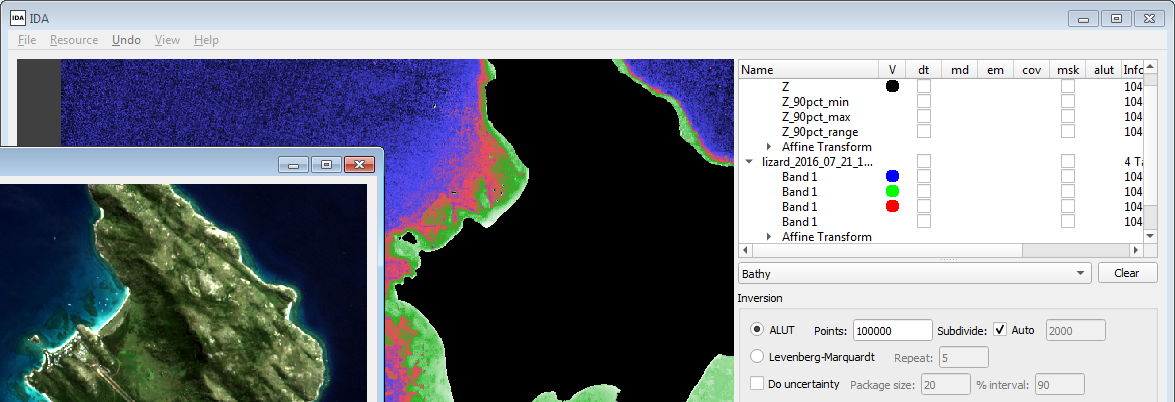
IDA has been designed as both research tool and for efficient use in a production environment. Processing can be conducted through a user-friendly GUI or scriptable command-line interface, enabling automated processing chains. Coupled with freely available Sentinel-2 and Landsat 8 data, IDA enables efficient production of satellite based bathymetry maps, bottom cover reflectance, and other outputs.
IDA is available for Microsoft Windows and Linux.
Features
Fast implementation and efficient workflow
Physics-based SDB is computationally demanding and many implementations are too slow for practical production work. IDA is the only available implementation of the fast ALUT (adaptive look-up table) SDB inversion algorithm, and is typically several orders of magnitude faster than other implementations. In addition, IDA provides per-pixel uncertainty propagation giving more accurate depth estimates and confidence intervals at every pixel. IDA also includes a novel and fast atmospheric correction algorithm specifically for SDB. Processing 100's of full Sentinel-2 tiles is a practical proposition with IDA.
Suitable for use with any optical satellite data
IDA can be used with any optical satellite data. Tested data sources include Sentinel-2 MSI, Landsat 8 OLI, Pleiades, SPOT-6, Worldview-2, 3, 4, RapidEye, QuickBird, IKONOS, GeoEye. IDA has also been used with hyperspectral airborne data. If you have specific requirements for image data compatibility please get in touch.

Additional shallow water mapping features
In addition to satellite derived bathymetry, IDA includes a number of tools for general shallow water mapping. This includes atmospheric correction, sun-glint correction, image segmentation, empirical bathymetry methods, depth invariant indices and an object-orientated random forest classifier. In particular, the physics-based bathymetry processing also produces estimates of water column optical properties and bottom reflectance as an output. The bottom reflectance can be used as input to a classifier for bottom cover map production.
Fully open methods
IDA contains no black-box algorithms, all the implemented methods are published in peer-review journals, and the full source code is available to licence holders.
Tried and tested
IDA is the actual code which has produced the results shown in numerous peer-reviewed publications. The software has been used for bathymetry production for over 15 years and applied to thousands of images, so its performance is well understood. IDA is currently in use worldwide in hydrographic offices, government agencies, universities and commercial sector companies.
Documentation
Comprehensive documentation includes step by step worked examples on how to use all the tools with example files included. Addtional support for specific applications or training in theory and workflow concepts are available separately.
Notes
While IDA provides a complete processing chain from imagery to map products it is not a replacement for more general image processing software and most users use IDA alongside standard commercial or free packages. SDB production is highly dependent on image quality, operator experience, and various workflow choices and quality checks that must be applied on a case-by-case basis. IDA is a tool, and like any tool can produce good or bad results depending on how (and to what) it is applied. The documentation is sufficient to learn how to operate the software, but it does not explain the theory of SDB or overall production workflow concepts. Training in these are available separately, please send an email to the address below to discuss further.
To discuss the suitability of IDA for your intended application, please get in touch j.d.hedley@numopt.com.
If you are looking for a company to produce a bathymetry or bottom cover map from satellite data, then Numerical Optics Ltd. does undertake a small amount of production work, or we may be able to provide a recommendation. See the consultancy web page for more information.
References
A selection of papers which include results produced with IDA:
- Seagrass depth distribution mirrors coastal development in the Mexican Caribbean
- Coral reef applications of Sentinel-2
- Satellite-derived bathymetry in optically complex waters
- Intercomparison of shallow water bathymetry, hydro‐optics, and benthos mapping techniques
- Derivation of High-Resolution Bathymetry from Multispectral Satellite Imagery
- Efficient radiative transfer model inversion for remote sensing applications